18.6°
Humid
Feels like 21°
Updated Sat 31 Oct 2026 4:49 pm AEDT
Severe Thunderstorm Warning
Issued at 4:14 pm Saturday, 31 October 2026.
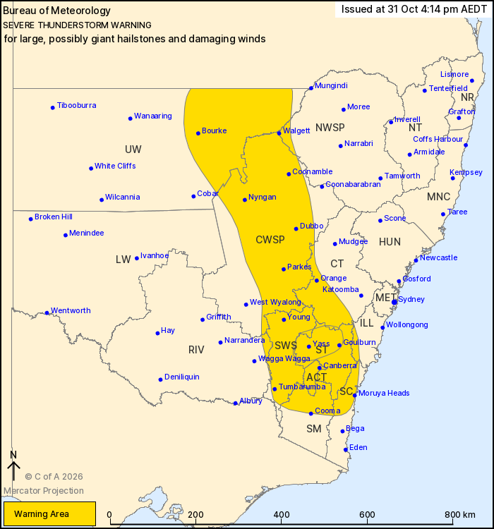
Scattered severe thunderstorms developing in the next few hours over the central and southeast inland of the state.
Warning Map
: A cold front will move eastwards across the south of NSW this afternoon and evening, tending to slow and stall over northern parts of the state. Moderate instability east of this feature, combined with moderate to strong winds in the upper levels, will aid in the development of isolated to scattered severe thunderstorms this afternoon and evening.

VERY DANGEROUS THUNDERSTORMS are likely to produce large, possibly giant hailstones and damaging winds over the next several hours in parts of the Southern Tablelands, Central Tablelands and South West Slopes districts. Locations which may be affected include Goulburn, Yass and Crookwell.

Severe thunderstorms are likely to produce damaging winds and large hailstones over the next several hours in the Southern Tablelands, Central West Slopes and Plains, South West Slopes, Australian Capital Territory and parts of the Illawarra, South Coast, Central Tablelands, Upper Western, Snowy Mountains, North West Slopes and Plains and Riverina districts. Locations which may be affected include Orange, Canberra, Goulburn, Dubbo, Bourke, Batemans Bay, Yass, Walgett, Parkes, Moruya Heads, Coonamble and Nyngan.

Severe thunderstorms are no longer occurring in the Lower Western district and the warning for this district is CANCELLED.

The next warning is due to be issued by 7:15 pm.
Min Temp
8.1°
at 6:22am
Max Temp
20.9°
at 12:44pm
10-min Avg. Wind
7 km/h
NE
Gusting
13 km/h
Max: 41 km/h at 11:33am
Rainfall
10.1 mm
since 9am
Humidity
86 %
Dew Point: 16.2°
Lightning Strikes
⚡️ 5
detected today
Recent Lightning
14 km
NNE at 4:38:28 pm
Forecast
Saturday 31 Oct
MIN
8°
MAX
22°
Rest of Today
Periods of rain at times during the day with thunderstorms possible. Gusty northwesterlies.
Tonight
A few showers this evening, easing later. A chance of fog patches.
Rainfall 7-10 mm
Rain 90%
Wind NW 45-70
Dew Pt 10°
Overnight Morning Afternoon Evening
↑ Sunrise 5:59 am
↓ Sunset 7:34 pm
Current Skycam
Recent Skycam Images
5 AM
7 AM
9 AM
11 AM
1 PM
3 PM
Live Fire Danger & Air Quality
🔥
Fire Danger
6
Catastrophic (100+)
Extreme (50+)
High (24+)
Moderate (12+)
No Rating
🌬️
PM2.5
5.9 μg/m³
Extremely Poor (150+)
Very Poor (50+)
Poor (25+)
Fair (12.5+)
Good
7-Day Observations
Menu Home Forecast Radar Observations
Enlarged warning map
Loaded successfully via ASPGWeather.com's Canberra server through Cloudflare (CMH edge) at 4:49:36pm AEDT on Saturday 31/10/2026. Rendered in 26 ms · Encrypted (HTTPS) · Visitor region US · Ray a530609e2f8c4bba-CMH